Guide · Tree-planting carbon projects
Carbon feasibility study: what it covers, what it costs and where it stops
A carbon feasibility study tells you, before you spend on project design, whether a tree-planting carbon project can work on your land: how much land is eligible, how much carbon the trees could remove, and how much of that could become credits. This guide explains the study step by step for ARR projects under VM0047, with pages from a real report.
What a carbon feasibility study is
Developing a carbon project costs years and a lot of money before the first credit is issued: a Project Design Document, stakeholder consultation, validation by an accredited body, registration, planting and monitoring. A feasibility study is the cheap step before all of that. It tests the assumptions that decide whether the rest is worth paying for.
The phrase is used for very different things. In heavy industry, a “carbon feasibility study” usually means carbon capture and storage. This guide is about nature-based carbon projects, and specifically about tree planting on land without forest, which carbon standards call ARR (afforestation, reforestation and revegetation). For ARR projects on the Verra registry the current methodology is VM0047, and that is the method our studies follow.
- Project typeARR, incl. agroforestry
- MethodologyVM0047
- Delivery2–3 or 5 business days
- PriceFrom $500
The questions a feasibility study answers
A good study gives a clear answer to five questions, and says how sure it is about each one:
- Can this project be studied under a carbon methodology at all? Planting trees on cropland or degraded grassland fits ARR. Protecting an existing forest does not; that is REDD+.
- How much of the land is eligible? Land that was forest in the last ten years, built-up land, water, wetland and very steep slopes drop out. On some sites that removes half the area; on others almost nothing.
- What would grow there? The climate, rainfall, dry season and altitude limit which species survive. A species that is invasive in the country is a red flag.
- How much carbon could the trees remove, and how much of that becomes credits? Gross removals are not credits. Uncertainty, the non-permanence buffer and leakage come off first. See gross vs net carbon credits.
- What has to be checked next? Land rights, community consent, the host country's rules and field data are not things a desktop study can settle. The study should list them.
How the study works, step by step
Each step uses the result of the one before. The eligible-area figure from step 3 is the same figure used in every later section, so the report never mixes three different area totals.
Boundary and intake
You upload the project boundary as a KML or KMZ and give each part a role: planting, agroforestry, preservation or reference. You say what you plan to plant, if you know, and when.
Method check
Before you pay, the platform checks the project type against the methods it runs. Today that is ARR under VM0047. If the project belongs to a family we cannot study yet, you are told then, not after.
Eligible area
Satellite datasets remove, pixel by pixel, land that was forest within the last ten years, built-up land, water and wetland, and slopes above 30°. What is left is the eligible area.
Climate, terrain and species
The site's rainfall, dry season, temperature and altitude are described, and your species are screened against them. If you name none, a shortlist is built from registered ARR projects in the same ecoregion.
Carbon removals
Gross removals over the project period come from IPCC 2019 Tier 1 growth rates for the site's ecological zone, in conservative, average and optimistic cases.
Gross to net
Uncertainty, the non-permanence buffer and leakage are deducted one by one, each with its basis, to give a net screening estimate.
Conclusion and next steps
A plain recommendation (proceed, proceed with conditions, or reconsider) and the fieldwork, legal checks and consultation needed before project design. Specialists review the report before it is released.
The data behind the study
A desktop study is only as good as its datasets, so the report names every one. All of them are published, global and free to inspect, which means anyone can check a result.
| Dataset | Publisher | Used for |
|---|---|---|
| IPCC 2019 Refinement | Intergovernmental Panel on Climate Change | Tier 1 sequestration rates by ecological zone |
| Hansen Global Forest Change | University of Maryland | Forest cover in 2000 and loss history |
| ESA WorldCover and ESRI land cover | European Space Agency, Esri | Land cover inside the boundary |
| JRC Global Surface Water | European Commission Joint Research Centre | Water and wetland exclusion |
| GHSL (Global Human Settlement Layer) | European Commission Joint Research Centre | Built-up land exclusion |
| Registered ARR projects | Public registry documents | Comparable projects and species in the ecoregion |
Slope comes from an elevation model (NASADEM). Ecological zones for the IPCC rates come from FAO. Each dataset has known limits: Hansen counts any vegetation over 5 m as tree cover, and land-cover products disagree with each other at field scale. The report records where those limits matter for your site.
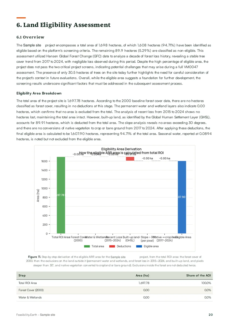 Eligible areaThe exclusion cascade, pixel by pixel
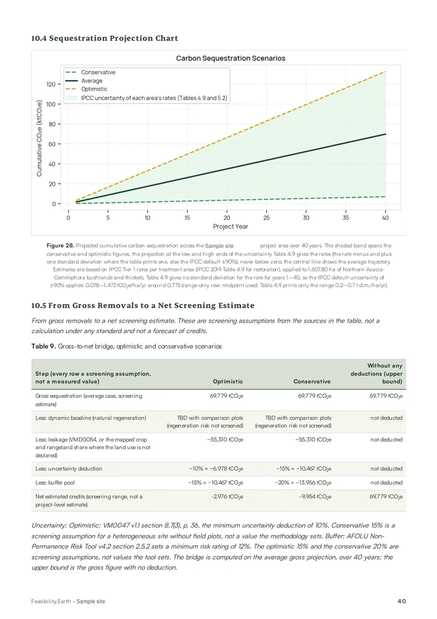 Carbon projectionConservative, average and optimistic cases
For more on what satellites can and cannot show, read satellite data in carbon project assessment. The full method is on the methodology page.
From gross removals to credits
The number most people remember from a feasibility study is the gross carbon figure. It is the least useful one for a business case. What matters is what is left after the standard's deductions, and when it arrives.
| Line | tCO2e | % of gross | Basis |
|---|---|---|---|
| Gross removals | 69,779 | 100% | IPCC Tier 1 projection, average case |
| Uncertainty deduction | −6,978 | −10% | 10%, the VM0047 minimum for ex-ante estimates |
| Non-permanence buffer | −10,467 | −15% | 15%, registry median of ARR projects |
| Leakage | −55,310 | −79% | VMD0054 defaults; land use not given, so the mapped crop and rangeland share counts as displaced |
| Net screening estimate | −2,976 | −4% | over 40 years, average case, on 1,608 ha of eligible land |
In this sample, leakage took 79% of gross removals. The order form did not say how the land is used today, so the report counted the projected area as displaced in proportion to the share of the site the land-cover map shows as crops and rangeland (98.2%), and applied the VMD0054 default values: the grazing or farming has to move somewhere else. On a site with no prior land use the deduction would be far smaller. That is exactly the kind of difference a study exists to find before you commit. The gross vs net guide explains each line, and the dynamic baseline that VM0047 applies during monitoring.
The net figure here is −2,976 tCO2e over 40 years on 1,608 ha of eligible land: the deductions are larger than the gross removals. It is a screening estimate, not a forecast of issued credits, and it is the kind of answer that is cheap to get before a project and expensive to get after.
Eligibility check or full feasibility study?
Most projects do not need everything at once. The eligibility check is a pre-feasibility screen that answers whether the land qualifies. The full study adds the carbon case.
| Eligibility Check | Full Feasibility Study | |
|---|---|---|
| Price | $500 | $7,500 |
| Delivery | 2–3 business days | 5 business days |
| Method check | Yes | Yes |
| Eligible area after exclusions | Yes | Yes |
| Key barriers and a proceed/stop recommendation | Yes | Yes |
| Climate, terrain and species screen | No | Yes |
| Gross carbon removals (three cases) | No | Yes |
| Gross-to-net table | No | Yes |
| Next steps before project design | Short | Full list |
| If the land does not qualify | Fee not refunded | 50% refunded |
 CoverAnonymised sample, East Africa
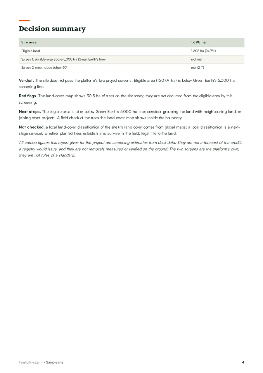 Decision summaryBoth screens, red flags and next steps on one page
Cost and timeline
Our prices are fixed: $500 for the Eligibility Check and $7,500 for the Full Feasibility Study, paid by card through Stripe when you order. Delivery is 2–3 and 5 business days from a complete intake. See pricing and deliverables.
Studies by consultancies are quoted per project. They often include things ours does not: site visits, soil sampling, a financial model, legal review of land tenure, or a stakeholder consultation. Those are worth paying for once a project has passed the desktop screen, not before. Before you compare two quotes, read what to compare when pricing a feasibility study.
Remember what comes after a positive study: project design, validation, registration, planting and years of monitoring before the first verified credit. The project development pathway sets out those stages.
The limits of a desktop study
A feasibility study narrows the risk. It does not remove it. Ours is a screening that follows VM0047; it is not a validation, a verification or a credit claim.
Good reasons a project fails at this stage are listed in why carbon projects fail feasibility.
After the study
If the study supports going ahead, the next steps are the ones it lists: fieldwork, land and consent checks, and then the Project Design Document. For projects that pass a full study, Green Earth Group offers project development support and, for some qualifying projects, considers co-investment. That is a separate decision, made case by case.
Specific guides for your project type: reforestation and ARR feasibility and agroforestry carbon credits.
Frequently asked questions
A carbon feasibility study is an early assessment of whether a proposed carbon project can work before money is spent on project design and certification. For a tree-planting (ARR) project it checks which land is eligible, estimates how much carbon the trees could remove, deducts what the standard requires, and lists the risks and the work still needed. It is a decision document, not a certification.
At Feasibility.Earth an Eligibility Check costs $500 and a Full Feasibility Study costs $7,500, for tree-planting projects under VM0047. Consultancy studies that include fieldwork, a financial model or legal review are priced per project and usually cost more, because they cover more. Compare the scope, not only the price.
Our Eligibility Check is delivered in 2–3 business days and the Full Feasibility Study in 5 business days, counted from a complete intake (boundary file and project answers). Studies that need field visits take longer because of travel, sampling and lab work.
A pre-feasibility study, which we call the Eligibility Check, answers one question: is enough of this land eligible to make a project worth studying? A full feasibility study goes on to species, carbon removals, the gross-to-net deductions and next steps. Start with the eligibility check if you are unsure the land qualifies.
Tree planting on land without forest: afforestation, reforestation and revegetation (ARR), including agroforestry, following the Verra methodology VM0047. We do not study REDD+, improved forest management, blue carbon, soil carbon or cookstove projects yet, and the method check tells you that before you pay.
No. A feasibility study is a desktop screening for your own decision. Validation is done by an accredited validation and verification body against the standard, after the Project Design Document is written. Our report is not a validation, a verification or a credit claim, and it says so on every page that shows a carbon figure.
A project boundary as a KML or KMZ file (from Google Earth, QGIS or ArcGIS), the role of each part of the boundary (planting, agroforestry, preservation or reference), what you plan to plant if you know it, and the planned start year. The intake form takes about 15 minutes.
You get a written explanation of the barriers. The $500 Eligibility Check is non-refundable. If the Full Feasibility Study concludes that the land does not qualify, 50% of the $7,500 fee is refunded.