Pre-feasibility · $500
Carbon project eligibility check: is your land eligible at all?
Before you pay for a full feasibility study, find out whether enough of your land can be counted. The eligibility check is our pre-feasibility screen for tree-planting carbon projects under VM0047: the eligible area, the barriers, and a clear recommendation in 2–3 business days.
Why check eligibility first
Most carbon projects that fail early fail on the land, not on the trees. A site that was forest eight years ago, a boundary that includes a village and a lake, or slopes too steep to plant can remove a large part of the area that a business plan assumed. A full carbon feasibility study will find that too, but the eligibility check finds it for $500 instead of $7,500.
- Price$500
- Delivery2–3 business days
- MethodVM0047 (ARR)
- InputKML or KMZ boundary
What the eligibility check looks at
Method check
Is this tree planting on land without forest (ARR), including agroforestry? If the project is avoided deforestation (REDD+), forest management, blue carbon or soil carbon, we cannot study it yet and you are told before you pay.
Boundary and land cover
Every part of the boundary is read with its role, and the land cover inside it is mapped from ESA WorldCover and ESRI land cover. New to boundary files? See how to make a KML boundary.
Forest history: the 10-year rule
Under the VCS Program, ARR projects cannot be on land where native ecosystems were cleared in the 10 years before the project starts. Forest cover in 2000 and forest loss since then come from Hansen Global Forest Change. Open land is not automatically eligible: see planting trees in grasslands and savannas.
Built-up land, water and wetland
Settlements and roads (GHSL) and open water and wetland (JRC Global Surface Water) come out of the plantable area.
Steep slopes
Slopes above 30° are removed, based on an elevation model. They are hard to plant and maintain and prone to erosion.
Barriers and recommendation
The eligible-area figure, the main barriers found, the information still missing, and a written recommendation: proceed to a full study, or not.
An example: what was excluded on a real site
In the anonymised sample study, a tree-planting project on dry bushland in East Africa, the boundary covered 1,698 ha. No land was classed as forest in 2000 and the exclusions were small, so 1,608 ha (94.71%) remained eligible:
- Built-up land: 89.9 ha
- Water and wetland: 0 ha
- Recent forest loss and conversion of native vegetation: 0 ha
- Steep slopes: 0 ha
That is a good result, and not a typical one. Sites near existing forest, in hills or along rivers can lose far more. A high eligible share is also not a pass: this site failed the platform's size screen, because 1,608 eligible ha is below Green Earth's 5,000 ha co-investment line. And eligible land is not the same as planted land. Here the boundary was one area with no planting plan, so the full study projected carbon on all 1,608 eligible ha and marked the figure as an upper bound. With planting zones, the carbon estimate uses the zones.
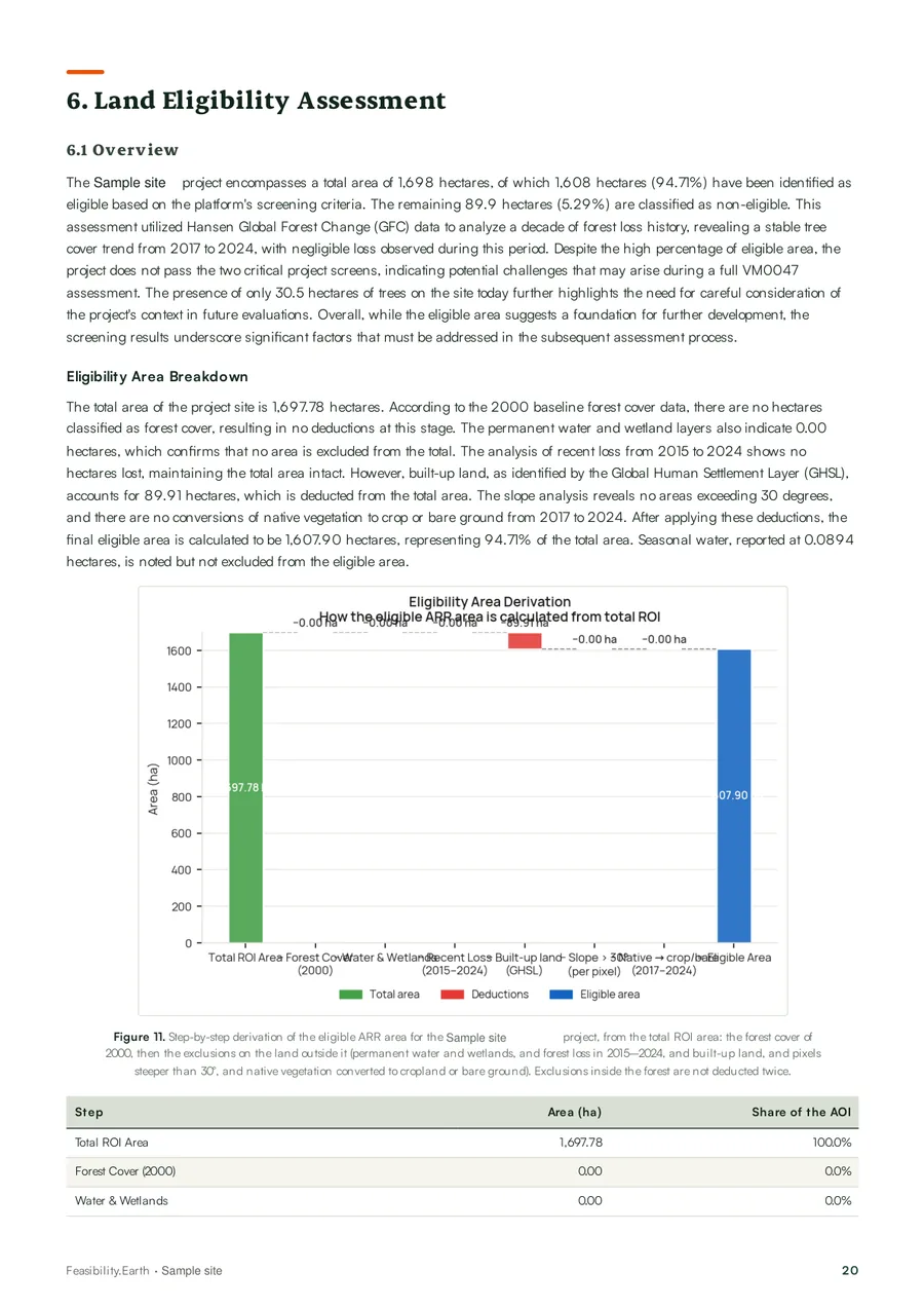 Eligible areaThe exclusion cascade, pixel by pixel
What you get
- The method check result: can the platform study this project, and under which method.
- The eligible area in hectares, with each exclusion and its dataset.
- The key barriers we found, and what information is missing.
- A clear written recommendation: proceed or not.
If the land does not qualify, the report explains why. The $500 fee is not refunded in that case; the answer is what you paid for.
What the eligibility check does not do
The host country's own forest definition (canopy cover, tree height, minimum area) can differ from the satellite threshold. Check it before you design the project. The methodology page lists the datasets and their limits.
Eligibility check or full study?
Start with the check if you are not sure the land qualifies: a large boundary, a site near forest, or land you have not walked. Go straight to the full study if you already know the land is open, unbuilt and plantable and you need the carbon case for a decision. The comparison table sets out what each one answers, and pricing has the refund terms.
Planting with crops or livestock? Read agroforestry carbon credits. Planning a forest restoration? Read reforestation project feasibility.
Frequently asked questions
It is a pre-feasibility screen for a tree-planting carbon project. It checks whether the project type fits a methodology we run (ARR under VM0047), removes land that cannot be counted (recent forest, built-up land, water and wetland, steep slopes) and tells you how much eligible land is left, what the main barriers are and whether a full study is worth it.
It costs $500 and is delivered in 2–3 business days after a complete intake. The fee is not refunded if the land does not qualify; you receive a written explanation of why.
Tree-planting (ARR) projects under the Verra VCS Program may not be on land where native ecosystems were cleared in the 10 years before the project starts. The check uses Hansen Global Forest Change to find forest cover and forest loss inside your boundary and removes that land from the eligible area.
No. It gives the eligible area and the barriers. Carbon removals, species and the gross-to-net deductions are part of the Full Feasibility Study ($7,500).
Yes. If you already know the land has not been forest recently and is not built up, wet or very steep, you can order the full study directly. It includes everything the eligibility check covers.
A KML or KMZ boundary, which you can draw in Google Earth, QGIS or ArcGIS. If the site has several parts, keep them as separate polygons and give each a role: planting, agroforestry, preservation or reference.